
Door County Land Trust Hikes
4.5star
8 reviews
1K+
Downloads

Everyone
info
About this app
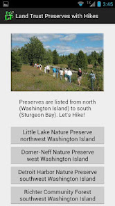
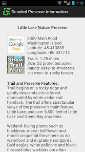
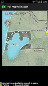
Shows trail maps, location and directions to 14 of the Door County Land Trust nature preserves. Includes info on ecological significance, plant types and wildlife observed while hiking.
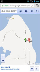
A paper map of these preserve locations was published in 2012 and updated in 2016, and this app is the electronic version of that map. In addition to the trail map images stored in the app, the app will locate the preserve on Google Maps in a browser window if desired.
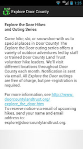
The app also provides information on wise use of the preserves, the "Explore the Door" guided hikes program, and the Door County Land Trust's mission.
A paper map of these preserve locations was published in 2012 and updated in 2016, and this app is the electronic version of that map. In addition to the trail map images stored in the app, the app will locate the preserve on Google Maps in a browser window if desired.
The app also provides information on wise use of the preserves, the "Explore the Door" guided hikes program, and the Door County Land Trust's mission.
Updated on
Safety starts with understanding how developers collect and share your data. Data privacy and security practices may vary based on your use, region, and age. The developer provided this information and may update it over time.

No data shared with third parties
Learn more about how developers declare sharing

No data collected
Learn more about how developers declare collection
Ratings and reviews
4.5
8 reviews

David Polich
- Flag inappropriate
December 13, 2020
my wife and I have hiked over 6 of these trails and found them to be very peaceful and scenic. Best time to go is spring time to see early wildflowers and autumn to view the fall colors. Most trails are easy terrain to moderate. Wear boots especially if wet or if you are traversing some of the rocky outcropping. I like rocks so the weathered Niagara limestone is very appealing. Many of the trails take you to the vista's or some waters edge. Enjoy and exercise.

A Google user
- Flag inappropriate
February 20, 2013
Great Tool!
1 person found this review helpful
What's new
Version 2.0 added Heins Creek Nature Preserve; updated some preserve data


